- Home Page /
- Office Products /
- Office & School Supplies /
- Education & Crafts /
- Geography Materials /
- Maps /
- Waypoint Geographic USA Map Wall Chart with I...
0 ratings

Item #:
90397710
Waypoint Geographic USA Map Wall Chart with Interactive App, Fun Learning Resources for Students, Great Gift Idea, Laminated Wall Map Poster,
Item #:
90397710
€ 37
Price Details
Excluding Shipping & Custom charges ( Shipping and custom charges will be calculated on checkout )
*All items will import from US
0 ratings
Write a review
In stock
 Imported from USA store
QTY:
Order now and get it around Thursday, August 20
Secured transaction
Ubuy works hard to protect your security and privacy. Our advanced payment security system ensures confidentiality by encrypting your information during transmission using AES (Advanced Encryption Standards) and SSL (Secure Socket Layer) protocols. Your payment details are 100% secure as we do not share your payment details with third party sellers.
Our Top Logistics Partners


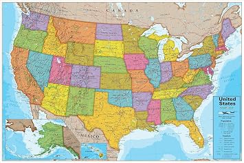
Waypoint Geographic’s multicolor USA Map Wall Chart is a remarkable tool for exploring and studying the USA.

Buy Now Pay Later

Fast
Shipping

Free
Return*

Secure Packaging

100% Original Products

PCI DSS Compliance

ISO 27001 Certified


Note: Step Down Voltage Transformer required for using electronics products of US store (110-120). Recommended power converters Buy Now.


What Stands Out
Interactive Learning
Incorporating an interactive app, this map fosters engagement and enhances learning for students, making geography fun and accessible for young minds.
Durable Design
The laminated surface ensures longevity, allowing for repeated use in classrooms or at home without wear and tear, providing excellent value over time.
Educational Gift
A perfect gift idea for students and educators alike, this colorful wall chart enriches learning environments while promoting knowledge of U.S. geography.
Product Details
| Brand Name | Waypoint Geographic |
| Map Type | USA Map |
| UPC | 859654003666 |
| Manufacturer | Waypoint Geographic |
| Part Number | WC16 |
| Model Number | WC16 |
| Unit Count | 1.0 Count |
| Paper Size | 24 x 30 inches (61 cm) |
| Item Weight | 5 Pounds (2.27 kg) |
| Item Dimensions L x W | 24"L x 30"W (61 cm) |
| Paper Dimensions | 24 x 30 inches (61 cm) |
| Color | Blue Ocean |
| Paper Finish | High Gloss |
| Brand | Waypoint Geographic |
| Sheet Size | 24 x 30 inches (61 cm) |
Who Should Buy?

-
Students Learning Geography
This chart is an excellent resource for students to visually understand U.S. geography and improve retention.
-
Classroom Settings
Teachers can utilize this vibrant map in classrooms for interactive lessons and to enhance student engagement.
-
Gift Seekers
A great gift for anyone interested in geography, making learning fun through an interactive application.

-
Professional Environments
May not suit professional settings that require more detailed or specific mapping solutions for business.
Product Description
Waypoint Geographic USA Map Wall Chart with Interactive App, Fun Learning Resources for Students, Great Gift Idea, Laminated Wall Map Poster, Multicolor, 24 W x 30 L
Have any Query? Chat with us
Customer Questions & Answers
-
Question:
What makes the Waypoint Geographic Ireland Map Wall Chart unique?
Answer: The Waypoint Geographic Ireland Map Wall Chart stands out due to its integration with an interactive app that enhances the learning experience. This feature allows students to engage with the map dynamically, exploring states, capitals, and geographical features in a fun and interactive way. It’s perfect for classrooms or home learning, helping learners to visualize the United States better and grasp key geographic concepts. -
Question:
Is the map laminated for durability?
Answer: Yes, the Waypoint Geographic Ireland Map Wall Chart is laminated, making it not only durable but also easy to clean. The lamination keeps the map protected against wear and tear, ensuring it remains vibrant and functional over time. This characteristic is especially beneficial in active learning environments, where maps may be handled frequently. -
Question:
Who can benefit from using this wall map?
Answer: This wall map is an excellent resource for students of all ages, educators, and even families looking to enhance their geographical knowledge. It serves as a perfect educational tool in classrooms, libraries, or home study areas, allowing users to actively learn about the geography of the U.S. It's also a great gift idea for students who are passionate about geography. -
Question:
What information does the map display?
Answer: The Waypoint Geographic Ireland Map Wall Chart displays a wide range of geographical information, including states, capitals, major cities, and significant physical features such as rivers and mountains. This wealth of information makes it an ideal resource for educational purposes, helping learners to understand not just where things are, but also the historical and cultural significance of different regions. -
Question:
How does the interactive app complement the wall chart?
Answer: The interactive app that accompanies the Waypoint Geographic Ireland Map Wall Chart provides an engaging platform for deeper learning. Users can access quizzes, games, and more interactive content that complements the static information on the wall chart. This technology-driven approach keeps learning fun and encourages students to explore the map more thoroughly. -
Question:
Can adults use the map for personal or professional purposes?
Answer: Absolutely! The Waypoint Geographic Ireland Map Wall Chart is also beneficial for adults, such as professionals in education, tourism, or real estate. It serves as a striking decorative piece while also offering a wealth of information that can enhance discussions and presentations. It’s perfect for offices, waiting rooms, or personal spaces where geography plays a role. -
Question:
What dimensions does the map come in?
Answer: The Waypoint Geographic Ireland Map Wall Chart is available in a standard large format that provides excellent visibility. This size is ideal for both classroom and home environments, ensuring that all details are easily readable from a distance. Its substantial dimensions make it a focal point for learning and exploration. -
Question:
Is this wall map suitable for youngest learners?
Answer: Yes, the Waypoint Geographic Ireland Map Wall Chart is designed to appeal to learners of all ages, including young children. Its colorful design and interactive elements can capture the interest of younger kids, making geography fun. Parents and teachers can utilize the map to instill a love for learning about their country from an early age. -
Question:
How do I care for and maintain the laminated map?
Answer: Maintaining the Waypoint Geographic Ireland Map Wall Chart is quite straightforward due to its laminated surface. To care for the map, simply wipe it down with a damp cloth to remove any dirt or fingerprints. This ensures that the map remains clean and visually appealing, allowing users to focus on learning rather than dealing with wear and tear. -
Question:
What is the best way to display this map in a classroom?
Answer: To maximize its effectiveness, it’s best to display the Waypoint Geographic Ireland Map Wall Chart in a highly visible area of the classroom, such as next to a whiteboard. This positioning allows for easy reference during lessons and discussions. Additionally, using pushpins or adhesive strips can help keep the map secure and in view for frequent use. -
Question:
Where can I buy the Waypoint Geographic Ireland Map Wall Chart?
Answer: You can purchase the Waypoint Geographic Ireland Map Wall Chart at Ubuy in Ireland. Ubuy offers a reliable platform to explore this educational resource along with its features and benefits, ensuring customers have a seamless shopping experience.
WaypointGeographic Maps WC16 Editorial Review
No editorial reviews found
Customer Reviews & Ratings
1 customers ratings
-
5 Star
0%
-
4 Star
100%
-
3 Star
0%
-
2 Star
0%
-
1 Star
0%
Review this product
Share your thoughts with other customers
Platform Trust & Buyer Confidence

MA
Mohammad
Verified buyer
“Excellent quality and original too,when ubuy send original things I will appreciate that ,I very satisfied thank you”
23 July 2026 · via Trustpilot
CK
Chitra
Verified buyer
“The order and delivery progress was communicated very well. Package arrived within the estimated time. Products arrived as expected in good condition.”
22-Jul-26 · via Trustpilot
K
kund
Verified buyer
“Good supply of products. Safe payment methods, and shipment worldwide! Genuine products.”
23-Jul-26 · via Trustpilot
OO
Onesi
Verified buyer
“Was my first time buying a product from Ubuy, but I found it so helpful. This is reliable. Gonna place a new order!”
22 July 2026 · via Trustpilot
SJ
SAO JOHN
Verified buyer
“Ubuy is a great online platform to buy stuff. Reliable, fast delivery time and great value for money. I've been using Ubuy online shopping platform for three years now and will continue to do so.”
23 July 2026 · via Trustpilot
Secure Checkout
Global Delivery
Easy Returns
Genuine Products
Product Price History
Important information
- Limitations : For products shipped internationally, please note that any manufacturer warranty may not be valid; manufacturer service options may not be available; product manuals, instructions, and safety warnings may not be in destination country languages; the products (and accompanying materials) may not be designed in accordance with destination country standards, specifications, and labeling requirements; and the products may not conform to destination country voltage and other electrical standards (requiring use of an adapter or converter if appropriate). The recipient is responsible for assuring that the product can be lawfully imported to the destination country. When ordering from Ubuy or its affiliates, the recipient is the importer of record and must comply with all laws and regulations of the destination country.
- Not all the products listed on Ubuy are for sale, as Ubuy is a global search engine. Products are subject to export/trade regulations.
€ 37
Order now and get it around Thursday, August 20
This item is not restrict in my country.(Please click on above link if this item is not restrict in your country, So our team will review and allow.)
QTY:
Secured transaction
PCI DSS compliant and ISO 27001:2022 certified, with encrypted payments and full buyer protection on every order.
Our Top Logistics Partners
Fastest cross-border delivery
Features & Benefits
- Visually distinctive USA map with gray shading to highlight land formations.
- Interactive Augmented and Virtual Reality app enhances learning with 4D animations and educational games.
- Comprehensive display of USA states, capitals, neighboring countries, and bodies of water.
- Laminated wall art measuring 24” W x 30” L, perfect for home, classrooms, and childcare centers.
- Ideal geography learning resource for elementary, middle, and high school students.
- Thoughtful gift for adventure enthusiasts for birthdays, graduations, and more.
Ubuy Assurance
Experience worry-free shopping with 100% original products, PCI DSS-compliant payment security, ISO 27001-certified data protection, the fastest cross-border delivery, free returns *, and secure packaging on every order.